|
(When
printing the tide tables, if you would like the row and column background
colors to be visible as they are on the screen, in your Internet Explorer,
click Tools > Options > Advanced, and then tick the 'print background
colors and images' box, (about halfway down the list), then click 'ok'.)
Tidal
Currents and their Effect
Since the Norfolk Broads consist of a group of inland lakes and their
connecting rivers, the effect of tide may seem of little consequence except
around Great Yarmouth, where the passage between the northern and southern
waters demands their respect. Their effect however, has an appreciable
influence elsewhere on sailing yachts and even motor cruisers.
The flow rate at Yarmouth
is around 4mph at mid-tide. Even as high as Potter Heigham and Horning,
it is still around 1mph. This may not sound very much, but when you consider
that the average Broads Authority speed limit is 5mph, (which is measured
'over the ground'), your boat speed through the water would therefore need to be 6mph
with an adverse tide, and only 4mph with a favorable tide.
Again, this may not
seem worth worrying about, but speed differences as small as this can
take a disproportionate amount of effort, (and noise level and fuel consumption)
to achieve with the type of boats used on the broads. Without getting
too technical, their 'displacement' type hulls are constrained by an absolute maximum possible
speed based on their waterline length, irrespective of the size of their
engine. Not only that, their fuel and engine efficiency reduces rapidly towards that limit.
A typical 27 foot
cruiser requires more than twice the power to achieve 6mph than it needs
for 4mph, and with smaller boats the difference is even greater, as their
potential maximum speed is disproportionately less.
|
sunrise (GMT)
|
3:42 |
|
sunset (GMT)
|
20:15 |
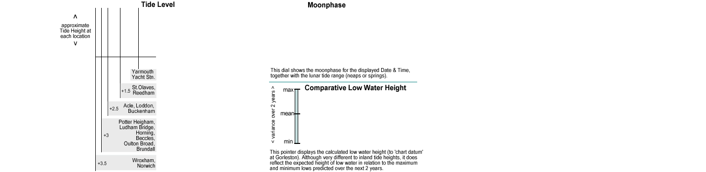
High
& Low Tide Time Variations over the System
The 'High' and 'Low' water times vary throughout the Broads because the
tide takes time to fill from the sea and then drain back through the rivers.
The Northern and Southern rivers also differ in the height range between
low and high water and the speed of the flood and ebb currents. This is
due to the fact that all of the northern rivers, (the Bure, Thurne &
Ant) connect to the sea through a very narrow and constricted section of the
Bure as it runs through Yarmouth. The southern rivers, (the Waveney &
the Yare) however, are much wider and deeper and have less restriction.
'Fighting' the current on the Yare or Waveney can be a quite discouraging
experience.
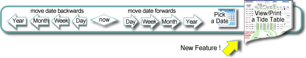
This Tide Calculator
shows the actual height at key points on the system for the date and
time displayed, together with the next predicted low and high tide
at those points. It initially defaults to now (today, this instant), but you can change the date and time for a new prediction with the buttons provided.
The calculations (as
with all Broads tide predictions), are reasonably accurate as regards high
and low water times, but the amount of rise and fall is greatly affected
by wind and rain conditions. If you are planning to pass under a low bridge,
such as Potter Heigham through to Hickling, you cannot always presume
that 'low water' will be any lower than 'high water' !!
If there has been
high rainfall or if the winds in the North Sea are of any strength and
from the North or North east, they tend to push the surface level of the North Sea down to
the narrows of the Dover Straits and keep the sea level high at Great
Yarmouth. This then has the unfortunate effect of preventing the ebb tide from exiting
to the sea, resulting in no low water. Passage through Potter & Wroxham bridges, (for average height
cruisers) is frequently blocked for days at a time, particularly in late
summer/Autumn.
Therefore,
if you planning a holiday cruise in advance to pass under these bridges,
you are well advised to leave your plans flexible, and consult the Bridge
Pilots nearer the day. (Their use at Potter Heigham is mandatory
for hired craft anyway.)
The
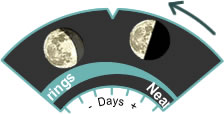
effect of Neaps & Springs
Tide height ranges vary as a result of the gravitational pull on the Oceans by the moon
and the sun. At fortnightly intervals, these act either in opposition, or
together and have a significant effect on High and Low water levels.
The comparative
low water height indicator shows graphically the variations in low
water tide height at Gorleston Bar. The 'max', 'average' and 'min' values
are based over a three year period of measurement. The figure shown is
the actual variance in metres above 'chart datum'. This has no significance
within the Broads waterways, but does reasonably reflect the comparative
heights between successive low tides.
During 'Springs', (about 3 days after Full or New Moons), the sun and
moon exert the most pull on the sea, and we experience both 'higher' high tides and 'lower' low tides than average. During 'Neaps' (around the half moon periods),
the sun and moon's gravitational pull are no longer combined, and we then
experience less extremes in either, ie the low tides aren't as low, and the high tides aren't as high.
This poses an
interesting quandary when considering neaps and springs when planning ahead to pass under low bridges when you know things are tight and you haven't much clearance. During Low Tide Springs,
the water level is at it's absolute lowest, so gives the best clearance
for safe passage. The subsequent High Water level however, is higher than
usual, so you will need to plan for your return approx. 12 hours later
to coincide with the next low. If the passage is made however during a
Neap period, then you may well have enough clearance at high or low water, as the variation between them will not be so great.
|