 |
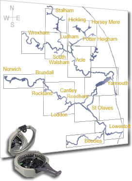
To take a virtual tour of the area, click any of the map outlines
on the keymap on the left to view that area at a much larger scale.
These virtual tour maps contain numerous red 'hotspots', which
can be clicked to view either photos  or links
  to web sites of local interest.
|
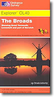
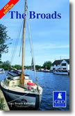
I receive many enquiries about which maps have the best coverage
of the Norfolk Broads Area.
I myself use three:
- the Ordnance Survey Explorer OL40, which
has the most waterside detail at 4cm-1km scale.
- The Geo 'The Broads' map at 2cm-1km scale,
which comprehensively covers both waterside detail and navigational
information.
- Hamilton's Navigations handbook and maps,
with detailed text descriptions of each bank.
All three are available from many local Broads businesses
or Amazon.co.uk
|
 |
|